Forest of Bowland Walks

Enjoy some truly beautiful scenery in this AONB in Lancashire. Highlights in the area include the gorgeous Trough of Bowland and the climb to the mysterious Pendle Hill with its fascinating history.
Use the links to view full route information including elevation profiles, interactive maps and GPS downloads.
You can also view an overview map of all the routes in the using the Forest of Bowland Walk Map>>
*New* - Walks and Cycle Routes Near Me Map - Waymarked Routes and Mountain Bike Trails>>
| Route Name | Photo | Distance | Description |
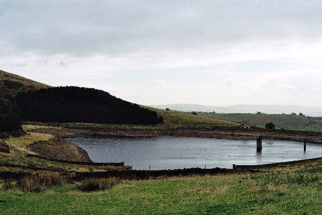
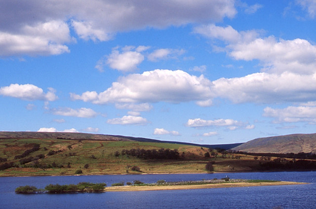
| Abbeystead Reservoir | 2.5 miles (4 km) | This short circular walk takes you around Abbeystead Reservoir in the Forest of Bowland. The reservoir has an impressive curved weir and is surrounded by some beautiful countryside. View Full Details>> | |
| Barley | 6.1 miles (9.8 km) | This attractive Lancsahire village is located in a scenic spot within the Forest of Bowland Area of Outstanding Natural Beauty. It's a splendid spot with picturesque stone cottages, a lovely picnic area, two excellent pubs and the pretty Barley Water running through the village. View Full Details>> | |
| Beacon Fell Country Park | 1.9 miles (3 km) | Explore 271 acres of woodland, moorland and farmland in the Forest of Bowland AONB. Beacon Fell is situated 266 metres (873 feet) above sea level giving fabulous views of Morecambe Bay, Blackpool Tower, Barrow, Pendle Hill, Longridge Fell, the Lake District Fells and the Isle of Man (on a clear day). At the hill summit there is a handy toposcope which shows all the different landmarks you can see. There are also several miles of lovely woodland walking trails, wooden sculptures, and a pretty tarn with a seating area at the eastern end. The excellent visitor centre includes with a wealth of information on the flora and fauna you can see on the fell. This includes bluebells in the spring and lovely heather in the autumn months. Beacon Fell is situated a few miles north of Preston and not far from Lytham and Blackpool. If you'd like to extend your walk you could head to the nearby Parlick and Fair Snape Fell where there is a wonderful footpath with fantastic views over the Forest of Bowland. View Full Details>> | |
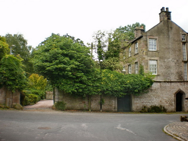
| Bentham | 3.3 miles (5.3 km) | This North Yorkshire town sits in a prime spot for walkers, close to the edge of both the Forest of Bowland AONB and the Yorkshire Dales National Park. View Full Details>> | |
| Black Moss Reservoir | 1.9 miles (3 km) | Enjoy a waterside walk around these two reservoirs near the Lancashire village of Barley. There's lovely views across the water to the Forest of Bowland countryside and lots of water loving wildlife to see too. Look out for Tufted duck, Common goldeneye and Eurasian curlew as you make your way through the area. You can start your walk from the car park in Barley, about half a mile from the reservoirs. Follow footpaths north east and you will soon reach the lower reservoir where there's a nice trail running around the water. During the walk you can enjoy splendid views towards Pendle Hill. You can extend your walk by following the Pendle Way to the hill summit for great views back down to the reservoirs. View Full Details>> | |
| Bleasdale Circle | 3.4 miles (5.5 km) | This walk visits the Bleasdale Stone Circle in the Forest of Bowland Area of Outstanding Natural Beauty. View Full Details>> | |
| Bolton by Bowland | 6.8 miles (11 km) | This delightful Lancashire village is in a great location for exploring the scenery of the lovely Forest of Bowland and Ribble Valley. View Full Details>> | |
| Brock Bottom | 1.1 miles (1.7 km) | This walk visits Brock Bottom near Garstang in the Forest of Bowland AONB. The area is something of a local hidden gem with peaceful waterside and woodland trails to enjoy. View Full Details>> | |
| Calder Vale | 1 mile (1.6 km) | This peaceful little village is located in a lovely spot on the edge of the Forest of Bowland AONB. View Full Details>> | |
| Chipping | 10.1 miles (16.2 km) | This attractive Lancashire village is located in a lovely position in the Forest of Bowland. This walk from the village picks up the long distance Hodder Way and follows it up to the delightful Dunsop Bridge which is the gateway to the popular Trough of Bowland. It's about a 10 mile hike up to the Trough from the village but you have the option of catching a bus part of the way back to save your legs! Starting in the village you head east to the River Hodder at Doeford Bridge. Cross the river and head north and it will take you past the splendid Inn at Whitewell before coming to Dunsop Bridge. The pretty village lies very close to the geographic centre of Great Britain at the confluence of the River Dunsop and the River Hodder. Head west and it will take you along the Langdon Brook to one of the most scenic areas of the AONB at the Trough of Bowland. View Full Details>> | |
| Clougha Pike | 5 miles (8 km) | This circular walk takes you to Clougha Pike in the Forest of Bowland. The hill is located a few miles east of Lancaster, reaching a height of 413 m (1,355 ft). Clougha Pike commands wonderful views over Morecambe Bay, Snowdonia and the Lake District Fells. It's a great area for wildlife too so keep your eyes peeled for grouse and hares on the way. You can park at the Rigg Lane car park (postcode below) just to the west of the hill. You then head towards Ottergear Bridge near Cragg Wood and the River Conder. The path then takes you towards Wisp Hill and Black Fell before coming to the Clougha Pike summit. Take a while to soak in the wonderful views. On a clear day you should be able to see the coast and beyond to the Isle of Man. The route then descends back to the car park via Windy Clough with views of Trough Brook on the way. An alternative, shorter route is to start from Rigg Farm and follow the Rowton Brook to the summit. The walk can be extended by continuing east along the path to Grit Fell and Ward's Stone, the highest hill in the Forest of Bowland. It can be quite a difficult walk though as it is a boggy area. Cyclists can reach the hill on regional route 90 which runs through Quernmore. View Full Details>> | |
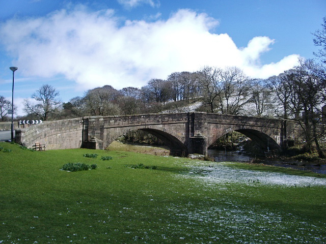
| Crook of Lune | 3.1 miles (5 km) | This circular walk visits a popular beauty spot on the Lune River in Lancaster. The route runs for about 3 miles on flat paths so is suitable for most abilities. It's a lovely area with views of the river, the old bridges and the surrounding countryside. The walk starts from the car park at the site where there's good facilities including toilets, picnic area and a cafe. From here you can pick up the Lune Valley Ramble and follow the waymarked trail north east along the river. After about a mile you'll come to a bridge which you can use to cross to the south side of the water. You can then follow footpaths south east back to the start point, passing through some small areas of woodland on the way. View Full Details>> | |
| Dolphinholme | 3.6 miles (5.8 km) | This pretty Lancashire village sits on the edge of the Forest of Bowland AONB. The remote settlement is a pleasant place for a stroll with several historic buildings in the lower village and a splendid local pub for a drink afterwards. View Full Details>> | |
| Downham | 4 miles (6.5 km) | A lovely circular walk from the Lancashire village of Downham, visiting the countryside to the east of the village. View Full Details>> | |
| Dunsop Bridge | 10.2 miles (16.4 km) | A challenging circular walk around the village of Dunsop Bridge in the Forest of Bowland. The pretty village lies very close to the geographic centre of Great Britain at the confluence of the River Dunsop and the River Hodder. It makes an excellent base for exploring some of the finest parts of the Forest of Bowland AONB. This walk includes a number of lovely waterside sections and several climbs to the fells in the surrounding area. The scenery is stunning with bubbling brooks, gorgeous valleys and wonderful views of the Bowland Hills for the duration of the route. The walk starts at the parking area in the village and follows country lanes and footpaths north west to the Langden Brook. A lovely waterside section takes you through the Langden Valley and along the pretty brook to Langden Castle. At the castle you turn south and follow the equally attractive Bleasdale Water past Brown Berry Plain to Beasley's Steady. The route then turns east, passing Fair Oak Fell and Whitmore Fell before coming to Totridge Fell. The fell is the high point of the walk standing at a height of 496 m (1,627 ft). You'll find a trig point and splendid views over the area from the summit. The route then descends back to the country lane near the village before returning to the car park. View Full Details>> | |
| Forest of Bowland Walk | 67.7 miles (109 km) | A circular walk around the Forest of Bowland AONB in Lancashire. You start at Caton and visit Slaidburn, Clitheroe, and Garstang before returning to Caton. The walk begins with a lovely riverside stretch along the River Lune from Caton to Hornby. You continue to Slaidburn before following the River Ribble through Clitheroe and climbing Longridge Fell for some splendid views. The next section takes you to Calder Vale and then onto Garstang, passing Beacon Fell which is well worth a slight detour from the trail (see video). The final section takes you from Garstang to Caton passing Nicky Nook. View Full Details>> | |
| Gisburn Forest | 4 miles (6.5 km) | Enjoy miles of wonderful woodland walking and cycling trails in this large forest in the Forest of Bowland. Mountain bikers can enjoy a moderate 9.5km blue grade trail and a more challenging red grade trail. Walkers can enjoy 5 waymarked walks of varying lengths and difficulty. In the forest you will find wide, well surfaced trails taking you through mixed woodland and conifer plantation with a wide variety of wildlife to look out for in one of the hides. There are also becks, streams and waterfalls. View Full Details>> | |
| Inn at Whitewell | 10.3 miles (16.5 km) | Explore the Forest of Bowland AONB from the Inn at Whitewell on this lovely circular walk. The splendid inn is in a wonderful location next to the River Hodder near the Lancashire town of Clitheroe. It's a great place to stay for walkers with a number of fine footpaths to follow into the surrounding countryside. Starting at the inn you head north toward the noteworthy Dunsop Bridge. The pretty village lies very close to the geographic centre of Great Britain at the confluence of the River Dunsop and the River Hodder. From the village you can pick up a trail heading north along the River Dunsop, with woodland on either side. The path then bends round past Whin Fell to Brennand Farm where you head south through the wonderful Trough of Bowland. The 'Trough' is a particularly scenic area of the AONB with its gorgeous valleys, moorland and wooded areas. Follow the trails south through the scenic area to Sykes Farm where you pick up another waterside trail along the Langdon Brook. This will lead you back to Dunsop Bridge where you can follow the road back to the Inn at Whitewell. View Full Details>> | |
| Jeffrey Hill | 0.9 miles (1.5 km) | This walk visits the viewpoint at Jeffrey Hill in the Forest of Bowland in Lancashire. View Full Details>> | |
| Longridge Fell | 4.7 miles (7.5 km) | Enjoy a walk to the summit of England's most southerley fell on this wonderful circular walk in the Forest of Bowland. The walk begins at the car park at Turner Fold and takes you to the 1,148-ft (350-m) summit on woodland footpaths. There are fabulous views from the high point including the Fylde Coast, the Vale of Chipping, the fells of the Forest of Bowland (including Parlick, Fair Snape Fell and Beacon Fell), the Yorkshire Dales and on a clear day the Lake District fells. Longridge Fell is situated to the north of both Preston and Blackburn. View Full Details>> | |
| Lune Valley Ramble | 16.2 miles (26 km) | This lovely easy walk follows the River Lune from Lancaster to Kirkby Lonsdale in Cumbria. As well as the stunning riversde scenery there are wonderful views of the South Lakeland fells and the beautiful Crook o' Lune. The route is bounded by high moors and limestone hills with the Ingleborough, Whernside and Leck Fells making a magnificent backdrop to the walk. View Full Details>> | |
| Nicky Nook | 3.9 miles (6.2 km) | This circular walk takes you up a popular and delightful fell in the Forest of Bowland. The route runs for a distance of just under 4 miles and involves a moderate climb to the hill top. View Full Details>> | |
| Parlick and Fair Snape Fell | 4.3 miles (7 km) | This walk from Parlick Fell to Fair Snape Fell is considered one of the loveliest in the Forest of Bowland. The walk takes place on a very good footpath with wonderful views over the surrounding countryside from the high points. The walk starts at the parking area on Startifants Lane and climbs to Parlick Fell. You continue north to Fair Snape, passing Bindhurst Fell on the way. The summit stands at 520 m (1,710 ft) and commands wonderful views over Londridge Fell and Beacon Fell. The walk can also be started from the nearby village of Chipping. It's located about 2 miles south east of Parlick Fell and is a great place to stop for refreshments. If you'd like to continue your walking in the area then you could head to the nearby Beacon Fell Country Park for more wonderful views and woodland trails. View Full Details>> | |
| Pendle Hill | 4.7 miles (7.5 km) | This walk climbs to the summit of Pendle Hill in Lancashire. It starts in the delightful village of Barley and makes use of the Pendle Way long distance footpath to take you on a circular tour of the area. It's a steep climb but the path is pretty well defined for most of the way. From the 557 metre (1,827 ft) summit there are fabulous views over the Pennines to the east, the Bowland Fells to the northwest, and the West Pennine Moors to the south. After leaving the summit you descend to Boar Clough before enjoying two waterside stretches along the Upper and Lower Ogden Reservoirs. The path then leads you back into Barley. The area is famous for the Pendle Witch Trials. These took place in 1612 when twelve people from the area were charged with the murders of ten people by the use of witchcraft. Ten were subsequently found guilty and executed by hanging. View Full Details>> | |
| Pendle Hill Walk From Sabden | 5.9 miles (9.5 km) | This walk climbs to Pendle Hill from the village of Sabden in Lancashire. The village is located a few miles south west of the hill summit and makes for an alternative start point to the Pendle Hill walk from Barley. It's about a 3 mile walk from the village so roughly 6 miles there and back. View Full Details>> | |
| Pendle Hill Witches Walk | 6.2 miles (10 km) | This double looped trail travels through the area associated with the Pendle Witch Trials of 1612. During the trial twelve people from the area were charged with the murders of ten people by the use of witchcraft. Ten were subsequently found guilty and executed by hanging. The walk visits several local landmarks connected to the accused, while also exposing you to some lovely Lancashire scenery along the way. There's waterside sections along rivers and reservoirs with fine views of the surrounding Forest of Bowland hills to enjoy too. The walk starts from the car park and visitor centre in the village of Barley. Follow footpaths south to Newchurch where the Demdike family of Pendle Witches lived in the 17th century. The route continues past Faugh's Quarry where Demdike claimed to have met the devil who promised her that she could have anything she desired in return for her soul. Follow Well Head Road west before turning north on a footpath to the Ogden Reservoirs. Here the trail turns east along the lower reservoir back to Barley where you can begin the eastern loop of the trail. This starts by following White Hough Water east to Slacks Wood and Offa Hill. The route then turns south to the pretty village of Roughlee where another of the accused lived. You then pick up country lanes to take you past a waterfall to Thorney Holme. Here you pick up Hays Lane which takes you past Boothman Wood before returning you to Barley. In the village you can enjoy refreshments at the Pendle Inn which has a great menu and is very popular with weary walkers. View Full Details>> | |
| Pendle Way | 44.7 miles (72 km) | Follow the Pendle Way through Lancashire and visit Barnoldswick, Thornton-in-Craven, Wycoller, Reedley, Newchurch and Pendle Hill on this challenging walk. View Full Details>> | |
| Scorton | 5 miles (8 km) | A circular walk around the Lancashire village of Scorton. The route visits two pretty lakes and peaceful woodland with some moderate climbs providing great views from the high points. It's a lovely area with quiet country lanes, good footpaths and fine views over the Forest of Bowland AONB. The walk starts in the village centre and follows Snowhill Lane past Wyresdale Lake. The route then turns right, passing Potter's Hill Wood before turning south to Grizedale Reservoir. Follow paths along the northern side of the water before picking up a path along the Grizedale Brook through Grizedale Woods. The route then follows Tithe Barn lane back into the village centre. View Full Details>> | |
| Slaidburn | 11.2 miles (18 km) | This Lancashire village is located in a pretty area of the Ribble Valley. This walk from the village takes you to some of the highlights of the area including the River Hodder, Stocks Reservoir and Gisburn Forest. There's much to enjoy with riverside trails, woodland paths and wonderful views of the countryside of the Forest of Bowland. View Full Details>> | |
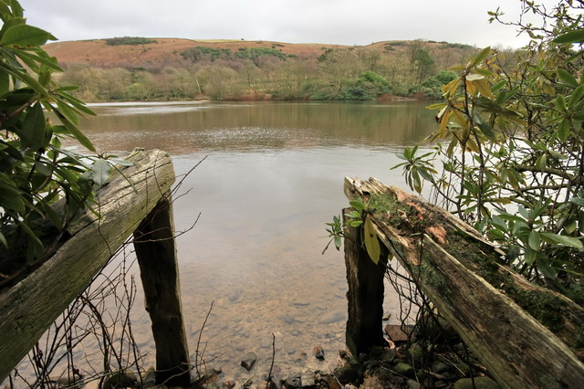
| Stocks Reservoir | 6.2 miles (10 km) | Enjoy a waterside circular walk around this lovely reservoir in the Forest of Bowland. The walk begins at the car park at the northern end of the reservoir and heads through the edge of Gisburn Forest and crosses the causeway. You then pick up a walking track which runs close to the waters edge, passing Rushton Hill and Ten Acre Hill on the way. On the western side you head to Eak Hill and Copped Hill Clough before a final woodland section through Gisburn Forest returns you to the car park. This is a lovely walk through woodland and farmland on well maintained, signed footpaths. There are splendid views of the surrounding countryside and hills plus ample opportunity for wildfowl spotting on the water. If you'd like to continue your walking in the area then you could head deeper into the adjacent Gisburn Forest. View Full Details>> | |
| Trough of Bowland | 8.1 miles (13 km) | Enjoy rivers, brooks, woodland and beautiful countryside on this circular walk in the Forest of Bowland AONB. View Full Details>> | |
| Wards Stone | 8.1 miles (13 km) | This walk climbs to Ward's Stone from the Jubilee Tower in the Forest of Bowland AONB. Ward's Stone is notable as the highest hill in the AONB. View Full Details>> | |
| Weets Hill | 5 miles (8 km) | This circular walk climbs to Weets Hill from Barnoldswick near the edge of the Forest of Bowland AONB. View Full Details>> | |
| Whitendale Hanging Stones | 0.6 miles (1 km) | Whitendale Hanging Stones are located in the picturesque Forest of Bowland, an Area of Outstanding Natural Beauty (AONB) in Lancashire, England. The stones are situated near the village of Dunsop Bridge, nestled in the heart of the Ribble Valley. You can reach the stones on a walk from Dunsop Bridge as illustrated on the video below. View Full Details>> | |
| Wolfhole Crag | 11.8 miles (19 km) | This walk takes you to the Tarnbrook Waterfalls and Wolfhole Crag in the Forest of Bowland AONB. View Full Details>> |