Biddulph Valley Way
![]()
![]() This circular route starts in Congleton and first follows the Biddulph Valley Way (a traffic free disused railway path) before turning round to return to Congleton. The route runs for just over 12 miles with views of the Macclesfield Canal and the Cheshire countryside. You'll also pass close to Biddulph Grange Country Park and Greenway Bank and Knypersley Reservoir which are well worth a small detour from the route.
This circular route starts in Congleton and first follows the Biddulph Valley Way (a traffic free disused railway path) before turning round to return to Congleton. The route runs for just over 12 miles with views of the Macclesfield Canal and the Cheshire countryside. You'll also pass close to Biddulph Grange Country Park and Greenway Bank and Knypersley Reservoir which are well worth a small detour from the route.
Biddulph Valley Way Ordnance Survey Map  - view and print off detailed OS map
Biddulph Valley Way Open Street Map  - view and print off detailed map
Biddulph Valley Way OS Map  - Mobile GPS OS Map with Location tracking
Biddulph Valley Way Open Street Map  - Mobile GPS Map with Location tracking
Pubs/Cafes
In Brown Lees you could stop at the Gardeners Arms pub for refreshments. It's a great place to go in the warmer months as it has a large outdoor seating area to relax in. You can find the pub in Brown Lees part way between Stoke and Biddulph at postcode ST8 6PH.
Further Information and Other Local Ideas
Part of the route uses National Cycle Route 55. The long distance trail runs from Ironbridge to Preston via Cheshire and Greater Manchester. Following the trail north would take you towards Macclesfield while heading south leads you towards Kidsgrove and Stoke on Trent. In Macclesfield you could pick up the Middlewood Way which runs to Marple along another section of disused railway.
Cycle Routes and Walking Routes Nearby
Photos

Running between Biddulph and Congleton along a disused railway line, the trail is very popular with walkers, horse-riders and cyclists. It forms part of Sustrans National Route 55, a cycle-way that will eventually link Ironbridge in Shropshire with Preston in Lancashire.

View of the path

The old platform, Biddulph Station Apart from a cottage just out of sight on the left, this is all that remains of what was once Biddulph Railway Station. The area to rear is now a carpark that opens onto the aptly named Smokies Way.

A view across the fields with Biddulph Country Park in the middle distance and Biddulph Moor on the top of the hill.

This is where the trail crosses Marsh Green Lane.

The old railway bridge. At one time traffic on Marsh Green Lane had to pass under the railway via the very low bridge on the left. When the railway was made redundant and turned into a public bridleway, instead of removing the bridge the road was diverted over the top.

Horse Riders on the path on a glorious summer day.

Stream between Holly Lane and the Biddulph Valley Way
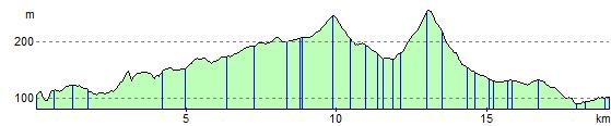
Elevation Profile