Birmingham to Walsall
13.7 miles (22 km)
![]()
![]() This route follows National Cycle Route 81 from Birmingham to Walsall. The route starts by the railway station in Birmingham and heads west along the Birmingham Canal to Smethwick. You then turn north towards West Bromwich where a lovely off road section through Sandwell Valley Country Park follows. The ride continues to Walsall on road before finishing at the train station.
This route follows National Cycle Route 81 from Birmingham to Walsall. The route starts by the railway station in Birmingham and heads west along the Birmingham Canal to Smethwick. You then turn north towards West Bromwich where a lovely off road section through Sandwell Valley Country Park follows. The ride continues to Walsall on road before finishing at the train station.
Birmingham to Walsall Ordnance Survey Map  - view and print off detailed OS map
Birmingham to Walsall Open Street Map  - view and print off detailed map
Birmingham to Walsall OS Map  - Mobile GPS OS Map with Location tracking
Birmingham to Walsall Open Street Map  - Mobile GPS Map with Location tracking
Cycle Routes and Walking Routes Nearby
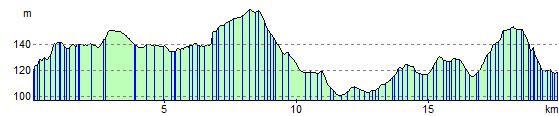
Elevation Profile