Calder Aire Link
![]()
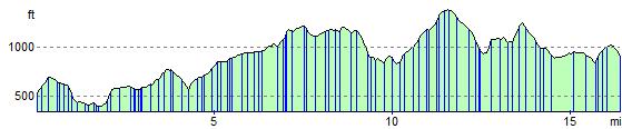
![]() This route provides a link from the Bingley St Ives Estate to the Pennine Bridleway Mary Towneley Loop in Calderdale. It is suitable for walkers and cyclists though a mountain bike is really needed due to the nature of some of the terrain on the path.
This route provides a link from the Bingley St Ives Estate to the Pennine Bridleway Mary Towneley Loop in Calderdale. It is suitable for walkers and cyclists though a mountain bike is really needed due to the nature of some of the terrain on the path.
You will pass Cullingworth and Oxenhope while there's some truly spectacular scenery as you pass the beautiful Leeming and Leeshaw Reservoirs before finishing near Gorple Reservoir and Widdop Reservoir.
Please click here for more information
Calder Aire Link Ordnance Survey Map  - view and print off detailed OS map
Calder Aire Link Open Street Map  - view and print off detailed map
Calder Aire Link OS Map  - Mobile GPS OS Map with Location tracking
Calder Aire Link Open Street Map  - Mobile GPS Map with Location tracking
Pubs/Cafes
Near Cullingworth you will pass the noteworthy Malt in Harden. The main draw here is a tremendous large garden area which seats 130 people. It's a great spot to relax in on a fine summer afternoon. The building also has an interesting history, dating back to 1550. It has taken on many faces, including a court room and a prison, of which the famous cell room still exists. A new Orangery has also been added, seating 33 people. Inside there's a cosy interior with three open fires for cold winter days. They do great food, have a large car park and are also dog friendly with water bowls dotted around the pub. You can find it on the Wilsden Road with a postcode of BD16 1BG for your sat navs. Near the pub you can also take a slight detour from the route to visit the delightful Goit Stock Waterfall. It's reachable on a footpath along Harden Beck from Harden Village.
Cycle Routes and Walking Routes Nearby
Elevation Profile