Castle Cary to Glastonbury
![]()
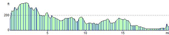
![]() This ride follows National Cycle Route 26 from Castle Cary to Glastonbury along quiet country roads.
This ride follows National Cycle Route 26 from Castle Cary to Glastonbury along quiet country roads.
You start at Castle Cary rail station and head south towards South Cadbury which is home to Cadbury Castle - thought to be King Arthur's Camelot by some. The route then turns north towards Baltonsborough before a waterside stretch along the River Brue takes you into Glastonbury where you finish near the historic abbey.
There's no rail station at Glastonbury but you can return to Castle Cary on the same route until Brue Farm where you can take a left towards Alford and then to castle Cary. This adds about 13 miles to the route for a total distance of about 34 miles.
Castle Cary to Glastonbury Ordnance Survey Map  - view and print off detailed OS map
Castle Cary to Glastonbury Open Street Map  - view and print off detailed map
Castle Cary to Glastonbury OS Map  - Mobile GPS OS Map with Location tracking
Castle Cary to Glastonbury Open Street Map  - Mobile GPS Map with Location tracking
Pubs/Cafes
You could stop at the Camelot in the little village of South Cadbury for some refreshments on the route. It's very conveniently located just a short stroll from the base of the ancient hill fort. The walls of the pub are even covered with information relating to the history of the castle site. There's a good menu and a lovely garden area to relax in on warmer days. You can find it in the village on Chapel Rd, with a postcode of BA22 7EX for your sat navs.
Cycle Routes and Walking Routes Nearby
Elevation Profile