Chesterfield to Sheffield
19 miles (30 km)

 This is a nice route that follows the Trans Pennine Trail from Chesterfield to Sheffield.
The route starts by the Chesterfield Canal and follows it for a few miles before a spell along a dismantled railway. The route finishes in the centre of Sheffield near the train station but apart from the finish is mainly off road.
Route highlights include the fine Renishaw Hall stately home at Eckington and shortly after the lovely Rother Valley Country Park with its expansive lake.
Chesterfield to Sheffield Ordnance Survey Map  - view and print off detailed OS map
Chesterfield to Sheffield Open Street Map  - view and print off detailed map
Chesterfield to Sheffield OS Map  - Mobile GPS OS Map with Location tracking
Chesterfield to Sheffield Open Street Map  - Mobile GPS Map with Location tracking
Cycle Routes and Walking Routes Nearby
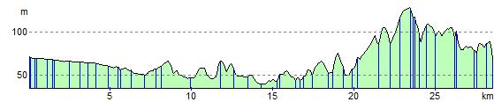
Elevation Profile