Chollerford Loop
![]()
![]() A moderately easy loop starting in Hexham. Pleasant and mostly quiet roads, some off road tarmac but suitable for all types of bike (there is a short MTB only alternative link between The Riding and Acomb). Best anti clockwise due to prevailing winds and gradient.
A moderately easy loop starting in Hexham. Pleasant and mostly quiet roads, some off road tarmac but suitable for all types of bike (there is a short MTB only alternative link between The Riding and Acomb). Best anti clockwise due to prevailing winds and gradient.
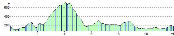
Leave Hexham heading North, after crossing the river, take tarmac bridle path on left just before A69. Turn right after crossing the A69 by bridge and then immediate left. Stiff climb between Acomb and the B6318 Military road, but never more than 10%. Fast descent to Cholleford along the Military Rd, then left at the roundabout to Chesters. Left after Chesters and left again to return to Hexham via the Hadrians Cycleway (National Cycle 72). Turn left immediately after crossing the South Tyne and follow the river back to Hexham.
Cycle shop, cafes and pubs in Hexham, cafe at the roundabout in Chollerford and pub at Bridge End. Sites of interest on the route include Chesters Roman fort and opposite on the South side of the river, substantial remains of the Roman bridge (free entry).
Chollerford Loop Ordnance Survey Map  - view and print off detailed OS map
Chollerford Loop Open Street Map  - view and print off detailed map
Chollerford Loop OS Map  - Mobile GPS OS Map with Location tracking
Chollerford Loop Open Street Map  - Mobile GPS Map with Location tracking
Elevation Profile