Coast and Castles Cycle Route
![]()
![]() The complete National Cycle Network Coast and Castles route from Newcastle to Edinburgh via Berwick Upon Tweed.
The complete National Cycle Network Coast and Castles route from Newcastle to Edinburgh via Berwick Upon Tweed.
The ride follows National Cycle Route 1 through Tyne and Wear, Northumbria and then into Scotland. With spectacular coastal scenery, riverside sections and views of the Scottish Hills and mountains there is something for everyone on this fabulous cycle route.
Scroll down for the maps and free gpx file for the route.
Please click here for more information
Coast and Castles Ordnance Survey Map  - view and print off detailed OS map
Coast and Castles Open Street Map  - view and print off detailed map
*New* - Walks and Cycle Routes Near Me Map - Waymarked Routes and Mountain Bike Trails>>
Coast and Castles OS Map  - Mobile GPS OS Map with Location tracking
Coast and Castles Open Street Map  - Mobile GPS Map with Location tracking
Cycle Routes and Walking Routes Nearby
Photos

Coast and Castles Route at Hud's Head

Footbridge at Lowsteads Links

Redshin Cove

Druridge Bay

Train on the main-line to Berwick-upon-Tweed

Near Scremerston

St Mary's Nature Reserve Just inland from St Mary's Island is this wetland nature reserve. Here you can look out for wildfowl including Teal, Mallard, Tufted Duck, Garganey, Wigeon and Moorhens. This viewing station lies just off the cycleway which carries the Coast and Castles Cycle Route (National Cycle Network route 1). Although slots are provided for viewing, the fence is so low that birdwatchers can rather more easily look over the top of the fence!

Eve Black Coastal Walkway and A193 At this point the Eve Black Walkway through the dunes between Seaton Sluice and Blyth runs alongside the A193 and long linear car park adjacent. The Walkway is followed by National Cycle Network route 1 (Coast and Castles route) and the European Cycle Network North Sea route. Before the recent construction of the Walkway, the cycle route ran alongside the road all the way between the two settlements.
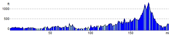
Elevation Profile