Deerness Valley Railway Path
![]()
![]() This cycle or walk along a dismantled railway line runs from Stonebridge to Crook through the beautiful Deerness Valley. The path passes the villages of Ushaw Moor and Esh Winning and and woodland at Holburn and Woodhouses Wood. There are also lovely waterside stretches along the River Deerness to enjoy.
This cycle or walk along a dismantled railway line runs from Stonebridge to Crook through the beautiful Deerness Valley. The path passes the villages of Ushaw Moor and Esh Winning and and woodland at Holburn and Woodhouses Wood. There are also lovely waterside stretches along the River Deerness to enjoy.
The path can be accessed to the west of the city of Durham.
The Brandon - Bishop Auckland Walk and the Lanchester Valley Walk run very close to the trail.
They also run along disused railway lines and are a great way to further explore the area.
Deerness Valley Railway Path Ordnance Survey Map  - view and print off detailed OS map
Deerness Valley Railway Path Open Street Map  - view and print off detailed map
Deerness Valley Railway Path OS Map  - Mobile GPS OS Map with Location tracking
Deerness Valley Railway Path Open Street Map  - Mobile GPS Map with Location tracking
Further Information and Other Local Ideas
For more walking ideas in the area see the County Durham Walks page.
Cycle Routes and Walking Routes Nearby
Photos

Deerness Valley Path, Ushaw Moor. The path is an attractive trail for walkers, cyclists and horse-riders which runs from Broom Park near Durham to Crook. The site of the old station lies beyond the road crossing.

A cycle rests against a gate by a path sign near Stanley Crook.

A good view down the trail.

Unlike most railway paths, there is a significant length of this path which while following the railway's alignment does not stick to the railway's grade. The path is seen here crossing a private road.

New Brancepeth

Walker and cyclist
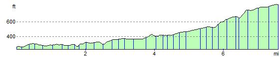
Elevation Profile