Didcot to Wantage
11.2 miles (18 km)
![]()
![]() This is a very leisurely ride taking place on off road tracks/paths and quiet country lanes from Didcot to Wantage.
This is a very leisurely ride taking place on off road tracks/paths and quiet country lanes from Didcot to Wantage.
The ride follows National Cycle route 44 and benefits from links to the Berkshire downs.
Highlights on the route are the pretty villages of Hagbourne and Lockinge and some lovely Oxfordshire scenery.
Didcot to Wantage Ordnance Survey Map  - view and print off detailed OS map
Didcot to Wantage Open Street Map  - view and print off detailed map
Didcot to Wantage OS Map  - Mobile GPS OS Map with Location tracking
Didcot to Wantage Open Street Map  - Mobile GPS Map with Location tracking
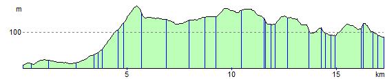
Elevation Profile