Doncaster to Sheffield
31.1 miles (50 km)
![]()
![]() This lovely route follows the Trans Pennine Trail from Doncaster to Sheffield.
This lovely route follows the Trans Pennine Trail from Doncaster to Sheffield.
You will follow first the River Don to Conisbrough, passing Sprotborough Weir and Conisbrough Viaduct as you go. The route then follows the River Dearne through Adwick and Bolton on Dearne with Manvers Lake and the Denaby Ings Nature Reserve highlights on this section. The route continues to Elsecar and Chapeltown before the final section along the River Don takes you into Sheffield.
Doncaster to Sheffield Ordnance Survey Map  - view and print off detailed OS map
Doncaster to Sheffield Open Street Map  - view and print off detailed map
Doncaster to Sheffield OS Map  - Mobile GPS OS Map with Location tracking
Doncaster to Sheffield Open Street Map  - Mobile GPS Map with Location tracking
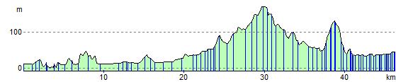
Cycle Routes and Walking Routes Nearby
Elevation Profile