Edinburgh to Bathgate
26.1 miles (42 km)
![]()
![]() Travel along National Cycle Route 75 and enjoy lovely waterside runs along the Union Canal and the River Almond.
Travel along National Cycle Route 75 and enjoy lovely waterside runs along the Union Canal and the River Almond.
The route starts in the centre of Edinburgh, near the famous castle, and soon joins the traffic free canal side path taking you to Balerno. You continue on road to East Calder where you join another scenic traffic free stretch along the River Almond taking you through Livingston. The final stretch takes you from Livingston to Bathgate on more pleasant cycle tracks.
Edinburgh to Bathgate Ordnance Survey Map  - view and print off detailed OS map
Edinburgh to Bathgate Open Street Map  - view and print off detailed map
Edinburgh to Bathgate OS Map  - Mobile GPS OS Map with Location tracking
Edinburgh to Bathgate Open Street Map  - Mobile GPS Map with Location tracking
Cycle Routes and Walking Routes Nearby
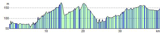
Elevation Profile