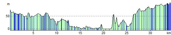
Edinburgh to Dunfermline
22.4 miles (36 km)
![]()
![]() Travel along National Cycle Route 1 and enjoy fabulous views of the Firth of Forth.
Travel along National Cycle Route 1 and enjoy fabulous views of the Firth of Forth.
The route starts in the centre of Edinburgh, near the famous castle, and heads through the suburbs of Roseburn and Barnton to the coast where you can enjoy a lovely traffic free section that runs along the Firth of Forth to Queensferry. Here you cross the Forth Road Bridge and continue on through Inverkeithing and then on to Dunfermline on a mixture of on road and off road sections.
Edinburgh to Dunfermline Ordnance Survey Map  - view and print off detailed OS map
Edinburgh to Dunfermline Open Street Map  - view and print off detailed map
Edinburgh to Dunfermline OS Map  - Mobile GPS OS Map with Location tracking
Edinburgh to Dunfermline Open Street Map  - Mobile GPS Map with Location tracking
Cycle Routes and Walking Routes Nearby
Elevation Profile