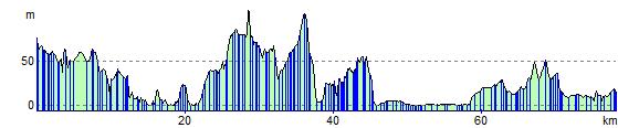
Edinburgh to Stirling
49.7 miles (80 km)
![]()
![]() Travel along National Cycle Routes 1 and 76 and enjoy splendid views of the Firth of Forth.
Travel along National Cycle Routes 1 and 76 and enjoy splendid views of the Firth of Forth.
The route starts in the centre of Edinburgh, near the famous castle, and follows National Cycle Route 1 through the suburbs of Roseburn and Barnton to the coast where you can enjoy a lovely traffic free section that runs along the Firth of Forth to Queensferry with views of the impressive Forth Road Bridge.
From Queensferry the route continues to Bo'ness on quiet roads save for a pleasant waterside stretch along the Union Canal at Craigton. You continue to Grangemouth where there are decent views of the Rivers Carron and Forth. The final stretch takes you to Stirling on a mixture of on road and traffic free sections.
Edinburgh to Stirling Ordnance Survey Map  - view and print off detailed OS map
Edinburgh to Stirling Open Street Map  - view and print off detailed map
Edinburgh to Stirling OS Map  - Mobile GPS OS Map with Location tracking
Edinburgh to Stirling Open Street Map  - Mobile GPS Map with Location tracking
Cycle Routes and Walking Routes Nearby
Elevation Profile