Farnham to Guildford
12.4 miles (20 km)
![]()
![]() Follow National Cycle Route 22 through the North Downs on this short but attractive route. The route starts near the train station in Farnham and follows a mixture of quiet roads and off road tracks through the Surrey countryside. You finish by crossing the River Wey in Guildford and then stopping at Guildford castle. Most of the route is on road but there are some pleasant traffic free sections through Puttenham Heath and Sunnydown to enjoy.
Follow National Cycle Route 22 through the North Downs on this short but attractive route. The route starts near the train station in Farnham and follows a mixture of quiet roads and off road tracks through the Surrey countryside. You finish by crossing the River Wey in Guildford and then stopping at Guildford castle. Most of the route is on road but there are some pleasant traffic free sections through Puttenham Heath and Sunnydown to enjoy.
Farnham to Guidlford Ordnance Survey Map  - view and print off detailed OS map
Farnham to Guidlford Open Street Map  - view and print off detailed map
Farnham to Guidlford OS Map  - Mobile GPS OS Map with Location tracking
Farnham to Guidlford Open Street Map  - Mobile GPS Map with Location tracking
Cycle Routes and Walking Routes Nearby
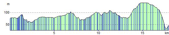
Elevation Profile