Gillingham to Warminster
![]()
![]() This route follows National Cycle Route 25 from Dorset to Wiltshire. The route starts near the train station in Dorset based Gillingham and heads north on quiet country roads. You'll soon come to Stourhead - an 18th century landscaped garden owned by the National Trust that is well worth a visit. You then continue onto a lovely stretch through the Longleat Estate and Longleat Centre Parcs. If you have time, Longleat House is another route highlight well worth stopping for, with beautiful grounds, a safari park and the delightful Heaven's Gate to enjoy. The final stretch takes you to Warminster on quiet roads.
This route follows National Cycle Route 25 from Dorset to Wiltshire. The route starts near the train station in Dorset based Gillingham and heads north on quiet country roads. You'll soon come to Stourhead - an 18th century landscaped garden owned by the National Trust that is well worth a visit. You then continue onto a lovely stretch through the Longleat Estate and Longleat Centre Parcs. If you have time, Longleat House is another route highlight well worth stopping for, with beautiful grounds, a safari park and the delightful Heaven's Gate to enjoy. The final stretch takes you to Warminster on quiet roads.
Gillingham to Warminster Ordnance Survey Map  - view and print off detailed OS map
Gillingham to Warminster Open Street Map  - view and print off detailed map
Gillingham to Warminster OS Map  - Mobile GPS OS Map with Location tracking
Gillingham to Warminster Open Street Map  - Mobile GPS Map with Location tracking
Pubs/Cafes
After your ride we recommend heading to the Rose & Crown pub in Warminster for refreshments. There's bar games, a good menu and a nice beer garden to sit out in during the summer months here. You can find it at 57 East St, with postcode: BA12 9BZ.
Also of note is the The George Inn at the village of Longbridge Deverill. The main attraction here is the lovely riverside garden, next to the River Wylye. You can find it at postcode BA12 7DG.
On the route you could stop at The Spread Eagle Inn on the Stourhead Estate. The eighteenth-century inn offers lunches, snacks, evening meals, cakes, tea and coffee, as well as a great selection of wines, beers, and gins. There's also a nice outdoor seating area to relax in during the summer months. You can find the inn at Church Lawn on the estate with postcode BA12 6QE for your sat navs.
Cycle Routes and Walking Routes Nearby
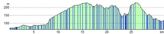
Elevation Profile