Glasgow to Paisley

 This lovely short easy ride takes you along National Cycle Route 75 from Glasgow to Paisley.
The ride starts with a pleasant run along the River Clyde before heading through Pollok Country Park with its National Trust owned 18th century house and attractive gardens (see video below).
A pleasant mixture of quiet roads and cycle tracks, including a stretch along White Cart Water, take you onto Paisley.
In Paisley pay a visit to the expansive Gleniffer Braes Country Park. There's wonderful viewpoints and miles of good cycling and walking trails to be found here.
Glasgow to Paisley Ordnance Survey Map  - view and print off detailed OS map
Glasgow to Paisley Open Street Map  - view and print off detailed map
Glasgow to Paisley OS Map  - Mobile GPS OS Map with Location tracking
Glasgow to Paisley Open Street Map  - Mobile GPS Map with Location tracking
Pubs/Cafes
In Paisley you could pay a visit to the Cross Stobs Inn. It's a pub of some note being housed in a picturesque seventeenth-century coach house. There's a cosy interior and a nice outdoor seating area for warmer days. You can find the inn at 6 Grahamston Park, Barrhead with a postcode of G78 1NS.
Cycle Routes and Walking Routes Nearby
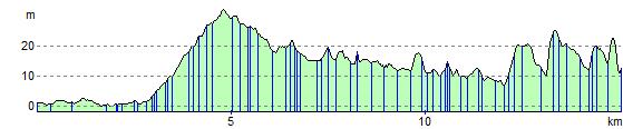
Elevation Profile