Gomshall and Hurt Wood
13.7 miles (22 km)
![]()
![]() Starting at Gomshall train station follow quiet country roads to Hurt Wood and then proceed onto Abinger Common on this short circular route.
Starting at Gomshall train station follow quiet country roads to Hurt Wood and then proceed onto Abinger Common on this short circular route.
Gomshall and Hurt Wood Ordnance Survey Map  - view and print off detailed OS map
Gomshall and Hurt Wood Open Street Map  - view and print off detailed map
Gomshall and Hurt Wood OS Map  - Mobile GPS OS Map with Location tracking
Gomshall and Hurt Wood Open Street Map  - Mobile GPS Map with Location tracking
Cycle Routes and Walking Routes Nearby
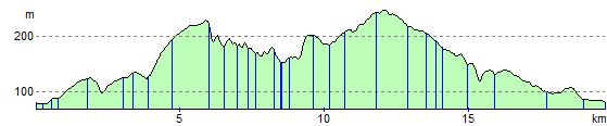
Elevation Profile