Grantham to Bottesford
11 miles (17 km)

 This route follows National Cycle Route 15 along the Grantham Canal.
You start by the tourist information centre in Grantham and soon join the towpath of the canal which takes you as far as Muston. From here you follow quiet roads to the finish point at Bottesford rail station.
Grantham to Bottesford Ordnance Survey Map  - view and print off detailed OS map
Grantham to Bottesford Open Street Map  - view and print off detailed map
Grantham to Bottesford OS Map  - Mobile GPS OS Map with Location tracking
Grantham to Bottesford Open Street Map  - Mobile GPS Map with Location tracking
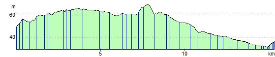
Elevation Profile