Greenwich to Gravesend
27 miles (43 km)

 Starting in Greenwich on the banks of the river Thames follow National Cycle Route 1 to Gravesend via Dartford.
The first section of the route takes you along the Thames path to Erith with views of Canary Wharf and the Millennium Dome as you go. You then join the Darent valley path taking you along the River Darent to Dartford. You continue to Gravesend on more off road tracks passing the enormous Bluewater shopping centre on the way.
Greenwich to Gravesend Ordnance Survey Map  - view and print off detailed OS map
Greenwich to Gravesend Open Street Map  - view and print off detailed map
Greenwich to Gravesend OS Map  - Mobile GPS OS Map with Location tracking
Greenwich to Gravesend Open Street Map  - Mobile GPS Map with Location tracking
Further Information and Other Local Ideas
At Erith the route links with the Cray Riverway. This waterside walk will take you south along the River Cray to the source at Orpington.
Cycle Routes and Walking Routes Nearby
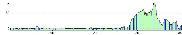
Elevation Profile