Guildford to Cranleigh and Horsham Cycle Route
![]()
![]() This route follows the Downs Link Bridlepath from Guildford to Horsham via Cranleigh.
This route follows the Downs Link Bridlepath from Guildford to Horsham via Cranleigh.
The route starts by Guildford rail and first follows the Wey Path along the River Wey before joining the Downs Link trail. This takes you through the North Downs along a disused railway line track bed before a short on road section takes you into Horsham, finishing at the train station.
Guildford to Horsham Ordnance Survey Map  - view and print off detailed OS map
Guildford to Horsham Open Street Map  - view and print off detailed map
*New* - Walks and Cycle Routes Near Me Map - Waymarked Routes and Mountain Bike Trails>>
Guildford to Horsham OS Map  - Mobile GPS OS Map with Location tracking
Guildford to Horsham Open Street Map  - Mobile GPS Map with Location tracking
Pubs/Cafes
The Seahorse pub in Shalford is a great place to stop for refreshments on the ride. There's a fine menu and an attractive outdoor space that’s ideal for a spot of al fresco dining when the sun makes a welcomed appearance. You can easily find it in the village at postcode GU4 8BU.
Further Information and Other Local Ideas
In Shalford you could stop to visit the historic Shalford Mill. The National Trust owned watermill dates from the 18th century and is well worth a visit if you have time. You can enjoy a fascinating guided tour of the mill and find out all about the its place in the history of Shalford. There's even the opportunity to buy a bag of Shalford Mill flour afterwards.
Cycle Routes and Walking Routes Nearby
Photos

Downs Link near St Martha's Hill, Guildford, Surrey

Cranleigh High Street.
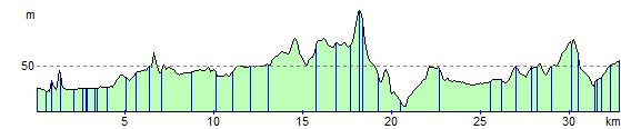
Elevation Profile