Haydon Bridge 18m Loop
18 miles (29 km)
![]()
![]() This route has something for everybody. There is some off road stuff which is possible on a road bike, though in recent wet weather, my 23c tyres weren't up to the last 1km! A 35mph descent into Haydon Bridge and mostly very quiet B roads. Allow 1 3/4 to 2 1/4 hours.
A must do is afternoon tea at Langley Castle, great value and terrific experience.
This route has something for everybody. There is some off road stuff which is possible on a road bike, though in recent wet weather, my 23c tyres weren't up to the last 1km! A 35mph descent into Haydon Bridge and mostly very quiet B roads. Allow 1 3/4 to 2 1/4 hours.
A must do is afternoon tea at Langley Castle, great value and terrific experience.
Haydon Bridge 18m Loop Ordnance Survey Map  - view and print off detailed OS map
Haydon Bridge 18m Loop Open Street Map  - view and print off detailed map
Haydon Bridge 18m Loop OS Map  - Mobile GPS OS Map with Location tracking
Haydon Bridge 18m Loop Open Street Map  - Mobile GPS Map with Location tracking
Cycle Routes and Walking Routes Nearby
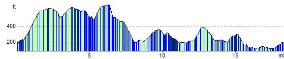
Elevation Profile