Horsham to Shoreham-By-Sea
23 miles (37 km)
![]()
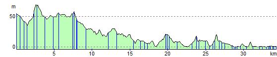
![]() Follow the Downs Link Bridlepath from Horsham to Henfield and Shoreham by Sea on this attractive, fairly flat route.
Follow the Downs Link Bridlepath from Horsham to Henfield and Shoreham by Sea on this attractive, fairly flat route.
The route starts by Horsham rail and follows off road tracks, a dismantled railway line and the River Adur before finishing at Shoreham harbour.
Horsham to Shoreham-By-Sea Ordnance Survey Map  - view and print off detailed OS map
Horsham to Shoreham-By-Sea Open Street Map  - view and print off detailed map
*New* - Walks and Cycle Routes Near Me Map - Waymarked Routes and Mountain Bike Trails>>
Horsham to Shoreham-By-Sea OS Map  - Mobile GPS OS Map with Location tracking
Horsham to Shoreham-By-Sea Open Street Map  - Mobile GPS Map with Location tracking
Cycle Routes and Walking Routes Nearby
Elevation Profile