Inverness to Carrbridge
![]()
![]() Travel along National Cycle routes 1 and 7 on this fascinating cycle ride which takes you past Culloden battlefield and the historic Bronze Age Clava Cairns.
Travel along National Cycle routes 1 and 7 on this fascinating cycle ride which takes you past Culloden battlefield and the historic Bronze Age Clava Cairns.
The ride starts on the River Ness at Inverness, heading east to the historic village of Culloden. You then pass the famous Culloden Battlefield where the Jacobites were defeated by the British in 1746.
Soon after you will come to Clava Cairns - a Bronze Age Circular chamber which is also well worth a look.
You continue mainly on road to Tomatin with stretches along the Rivers Nairn and Findhorn and splendid views of Loch Moy on the way. The final section passes through woods and along the River Dulnain to Carrbridge with much of it taking place on traffic free paths.
Inverness to Carrbridge Ordnance Survey Map  - view and print off detailed OS map
Inverness to Carrbridge Open Street Map  - view and print off detailed map
Inverness to Carrbridge OS Map  - Mobile GPS OS Map with Location tracking
Inverness to Carrbridge Open Street Map  - Mobile GPS Map with Location tracking
Further Information and Other Local Ideas
The Inverness Canal and Forest Walk will take you along the canal before heading to Craig Phadrig Forest, which lies just to the west of the city. The forest is a peaceful place for walks and includes a viewpoint with an Iron Age Hillfort.
On the south eastern side of the Culloden battlefield there's also the Clava Cairns and the Culloden Viaduct. The ancient Bronze Age site includes prehistoric burial monuments and the remains of a medieval chapel. It's also a short walk from the eye catching Culloden Viaduct which carries the Highland Main Line over the River Nairn.
Cycle Routes and Walking Routes Nearby
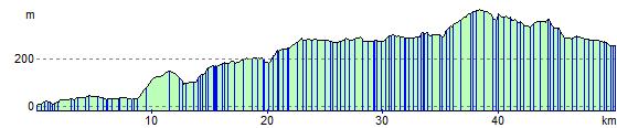
Elevation Profile