Inverness to Tain
![]()
![]() Travel along National Cycle route 1 from Inverness to Tain and enjoy some fabulous highland scenery as you pass through the Black Isle and cross both the Moray Firth and then the Cromarty Firth on the Cromarty Ferry.
Travel along National Cycle route 1 from Inverness to Tain and enjoy some fabulous highland scenery as you pass through the Black Isle and cross both the Moray Firth and then the Cromarty Firth on the Cromarty Ferry.
Inverness to Tain Ordnance Survey Map  - view and print off detailed OS map
Inverness to Tain Open Street Map  - view and print off detailed map
Inverness to Tain OS Map  - Mobile GPS OS Map with Location tracking
Inverness to Tain Open Street Map  - Mobile GPS Map with Location tracking
Further Information and Other Local Ideas
The Inverness Canal and Forest Walk will take you along the canal before heading to Craig Phadrig Forest, which lies just to the west of the city. The forest is a peaceful place for walks and includes a viewpoint with an Iron Age Hillfort.
Near Inverness you could head a short distance north east to visit one of the historic highlights of the area at Culloden Battlefield. There's a circular walking trail here which explores the site of the famous battle of 1746. The site includes an informative visitor centre where you can learn all about this fascinating conflict.
On the south eastern side of the battlefield there's also the Clava Cairns and the Culloden Viaduct. The ancient Bronze Age site includes prehistoric burial monuments and the remains of a medieval chapel. It's also a short walk from the eye catching Culloden Viaduct which carries the Highland Main Line over the River Nairn.
For more walking ideas in the area see the Scottish Highlands Walks page.
Cycle Routes and Walking Routes Nearby
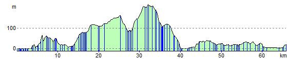
Elevation Profile