Killin to Callander
![]()
![]() Travel through the beautiful Loch Lomond and Trossachs National Park along National Cycle Route 7 on this stunning cycle ride. The route uses a dismantled railway line for most of the way so is also suitable for walkers.
Travel through the beautiful Loch Lomond and Trossachs National Park along National Cycle Route 7 on this stunning cycle ride. The route uses a dismantled railway line for most of the way so is also suitable for walkers.
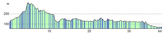
The ride starts at Killin following the River Dochart past the beautiful Falls of Dochart. You continue on the off road track through the scenic Glen Ogle towards Lochearnhead, where there are fantastic views of Loch Earn. From here you pass through Strathyre Forest to Balquhidder where you join a short on road section to Strathyre. The ride then joins a final traffic free section taking you around Loch Lubnaig to Callander.
Killin to Callander Ordnance Survey Map  - view and print off detailed OS map
Killin to Callander Open Street Map  - view and print off detailed map
Killin to Callander OS Map  - Mobile GPS OS Map with Location tracking
Killin to Callander Open Street Map  - Mobile GPS Map with Location tracking
Pubs/Cafes
In Killin the splendid Falls of Dochart Inn is well worthy of investigation. The inn is set in a great location next to the falls. You can sit outside and relax listening to the rushing water. Inside there's a cosy interior with a wood burning fire for colder weather. The inn has some history too, dating all the way back to the 1700s when it was previously a blacksmiths. You can find the inn at postcode FK21 8SL for your sat navs.
Further Information and Other Local Ideas
For more cycling and walking ideas in the area see the Loch Lomond and the Trossachs Cycle Routes and the Loch Lomond and the Trossachs Walks pages.
Cycle Routes and Walking Routes Nearby
Photos

Falls of Dochart, Killin

Lochan Lairg Cheile. Loch at the head of Glen Ogle, set in forested land just south of Killin.


Cycle track above Glen Ogle. Looking back towards Lochearnhead along the line of the disused Glen Ogle railway.

The Glen Ogle Viaduct

River Balvag in Strathyre

áAlluvial Fan on Loch Lubnaig. Taken from cycle track looking north across the loch. The course of the former railway can be seen in the foreground.

View of the trail just outside Callander with Ben Ledi Beyond
Elevation Profile