Lairg to Tongue
![]()
![]() Follow National Cycle Route 1 through the Scottish Highlands and enjoy fabulous views of the stunning Ben Hope and Ben Loyal mountains and the beautiful Loch Shin and Loch Loyal.
Follow National Cycle Route 1 through the Scottish Highlands and enjoy fabulous views of the stunning Ben Hope and Ben Loyal mountains and the beautiful Loch Shin and Loch Loyal.
The route takes place on (very) quiet country roads leading you through wooded areas and along the River Vargastie to Loch Naver. A splendid long section running along Loch Loyal and then Loch Craggie take you towards Tongue where there are wonderful views of the beautiful Kyle of Tongue.
In Lairg you can enjoy views of Loch Shin and the Loch Shin Hydro Dam.
Lairg to Tongue Ordnance Survey Map  - view and print off detailed OS map
Lairg to Tongue Open Street Map  - view and print off detailed map
Lairg to Tongue OS Map  - Mobile GPS OS Map with Location tracking
Lairg to Tongue Open Street Map  - Mobile GPS Map with Location tracking
Further Information and Other Local Ideas
Just south of Lairg there's one of the highlights of the area at the Falls of Shin. The beautiful falls are a great place to see salmon leaping during the late summer months. There's also a decent visitor centre, car park and cafe at the site.
Cycle Routes and Walking Routes Nearby
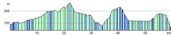
Elevation Profile