Leicester to Melton Mowbray
29.8 miles (48 km)
![]()
![]() This route follows National Cycle Route 63 through the Leicestershire countryside. You start near the tourist information centre in Leicester and head east to Goadby. Here you turn north passing through the pretty villages of Somerby and Little Dalby on your way to Melton Mowbray. The ride takes place mainly on quiet country roads/lanes and passes through several pretty Leicestershire villages. You finish at the train station in Melton Mowbray.
This route follows National Cycle Route 63 through the Leicestershire countryside. You start near the tourist information centre in Leicester and head east to Goadby. Here you turn north passing through the pretty villages of Somerby and Little Dalby on your way to Melton Mowbray. The ride takes place mainly on quiet country roads/lanes and passes through several pretty Leicestershire villages. You finish at the train station in Melton Mowbray.
Leicester to Melton Mowbray Ordnance Survey Map  - view and print off detailed OS map
Leicester to Melton Mowbray Open Street Map  - view and print off detailed map
Leicester to Melton Mowbray OS Map  - Mobile GPS OS Map with Location tracking
Leicester to Melton Mowbray Open Street Map  - Mobile GPS Map with Location tracking
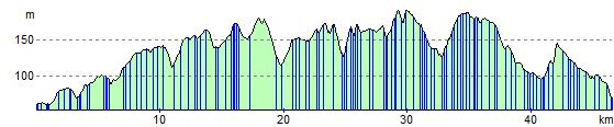
Elevation Profile