Llanberis Pass
![]()
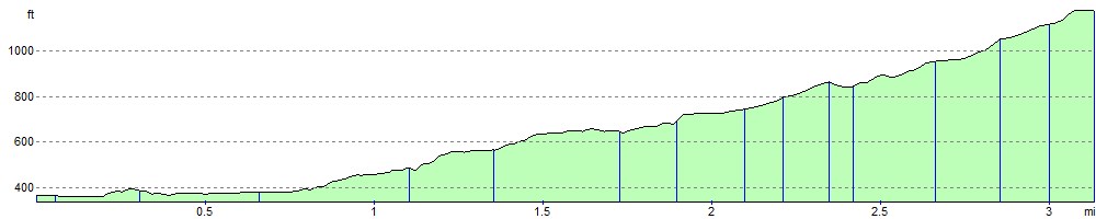
![]() This challenging climb in the Snowdonia National Park passes between the mountain ranges of the Glyderau and the Snowdon massif. The ride starts from the car park at Nant Peris and follows the A4086 to Pen-y-Pass. It's about a 3 mile ride (6 miles return journey) with stunning views and a high point of about 1180ft (359 metres). At Pen-y-Pass you can enjoy refreshment at the cafe before turning round and descending back to Nant Peris.
This challenging climb in the Snowdonia National Park passes between the mountain ranges of the Glyderau and the Snowdon massif. The ride starts from the car park at Nant Peris and follows the A4086 to Pen-y-Pass. It's about a 3 mile ride (6 miles return journey) with stunning views and a high point of about 1180ft (359 metres). At Pen-y-Pass you can enjoy refreshment at the cafe before turning round and descending back to Nant Peris.
You can follow the route by using the google street view link below. It'll give you a good idea of the climbing involved and the scenery you can enjoy on the route.
See the Snowdonia Cycle Routes page for more rides in the national park.
Postcode
LL55 4UF - Please note: Postcode may be approximate for some rural locationsLlanberis Pass Ordnance Survey Map  - view and print off detailed OS map
Llanberis Pass Open Street Map  - view and print off detailed map
Llanberis Pass OS Map  - Mobile GPS OS Map with Location tracking
Llanberis Pass Open Street Map  - Mobile GPS Map with Location tracking
Explore the Area with Google Street View 
Further Information and Other Local Ideas
To the west there's Lon Las Peris. The surfaced trail runs along a tree lined path on the old railway line. There's some nice views over Llyn Padarn from the lakeside path.
Cycle Routes and Walking Routes Nearby
Elevation Profile