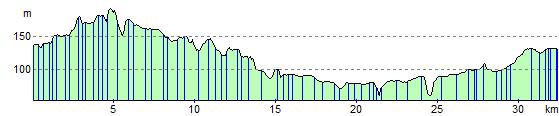
Macclesfield to Congleton
21.7 miles (35 km)
![]()
![]() This lovely ride follows the Cheshire Cycleway through Cheshire. You start in Macclesfield and head to Congleton on country roads with views of the Macclesfield canal and the River Dane as you go.
This lovely ride follows the Cheshire Cycleway through Cheshire. You start in Macclesfield and head to Congleton on country roads with views of the Macclesfield canal and the River Dane as you go.
You will also pass the 15th century Gawsworth Hall, Redesmere, and Astbury Mere Country Park on this route.
Macclesfield to Congleton Ordnance Survey Map  - view and print off detailed OS map
Macclesfield to Congleton Open Street Map  - view and print off detailed map
Macclesfield to Congleton OS Map  - Mobile GPS OS Map with Location tracking
Macclesfield to Congleton Open Street Map  - Mobile GPS Map with Location tracking
Cycle Routes and Walking Routes Nearby
Elevation Profile