Newton Abbot to Totnes
21.7 miles (35 km)
![]()
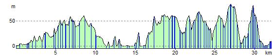
![]() This route starts near Newton Abbot train station and heads south east along future National Cycle Route 28 towards Torquay. You'll then follow a coastal path to Paignton before heading inland towards Totnes on a series of quiet roads and tracks. You'll finish by crossing the River Dart in Totnes.
This route starts near Newton Abbot train station and heads south east along future National Cycle Route 28 towards Torquay. You'll then follow a coastal path to Paignton before heading inland towards Totnes on a series of quiet roads and tracks. You'll finish by crossing the River Dart in Totnes.
Highlights on this route include the splendid views of Torbay.
Newton Abbot to Totnes Ordnance Survey Map  - view and print off detailed OS map
Newton Abbot to Totnes Open Street Map  - view and print off detailed map
Newton Abbot to Totnes OS Map  - Mobile GPS OS Map with Location tracking
Newton Abbot to Totnes Open Street Map  - Mobile GPS Map with Location tracking
Cycle Routes and Walking Routes Nearby
Elevation Profile