Plymouth to Looe
![]()
![]() This route follows National Cycle routes 27 and 2 from Plymouth in Devon to Looe in Cornwall. The route starts on the south west coast path in Plymouth following it to the Cremyll Ferry which will take you across the water into Cornwall. There is then a nice off road section through Mount Edgcumbe Country Park before rejoining the South West Coast path with its splendid views of the beautiful Whitsand Bay (below). The route continues to Looe with more spectacular coastal scenery to enjoy including views of Tregantle fort and the lovely seaside village of Seaton.
This route follows National Cycle routes 27 and 2 from Plymouth in Devon to Looe in Cornwall. The route starts on the south west coast path in Plymouth following it to the Cremyll Ferry which will take you across the water into Cornwall. There is then a nice off road section through Mount Edgcumbe Country Park before rejoining the South West Coast path with its splendid views of the beautiful Whitsand Bay (below). The route continues to Looe with more spectacular coastal scenery to enjoy including views of Tregantle fort and the lovely seaside village of Seaton.
Plymouth to Looe Ordnance Survey Map  - view and print off detailed OS map
Plymouth to Looe Open Street Map  - view and print off detailed map
Plymouth to Looe OS Map  - Mobile GPS OS Map with Location tracking
Plymouth to Looe Open Street Map  - Mobile GPS Map with Location tracking
Pubs/Cafes
The Jolly Sailor in Looe is a historic pub of some note. It was originally established in 1516 making it one of the oldest pubs in England. Affectionately known as 'the Jolly' by the locals, it has been a place of rest and recreation for seafarers and travellers alike for centuries. Inside the main beam in the pub was taken from a French ship of the line at the Battle of Trafalgar in 1805. The ship was captured and renamed The Indefatigable. When she was later broken up, the landlord of the time arranged for the beam to be installed in the main bar and it remains there to this day. The pub has been refurbished to a very high standard, making it one of the most pleasant, as well as the most characterful of places to drink or stay in the town. You can find the pub on Princes Square, Looe at postcode PL13 2EP.
Cycle Routes and Walking Routes Nearby
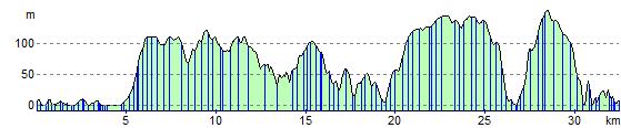
Elevation Profile