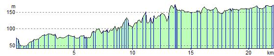
Pontypridd to Merthyr Tydfil
14.3 miles (23 km)
![]()
![]() Follow the Taff Trail and National Cycle Route 8 on this short pleasant route. The route mainly follows the trackbed of a disused railway line along the River Taff, making for a fairly easy traffic free ride. It's also very accessible with several train stations running along the course of the route.
Follow the Taff Trail and National Cycle Route 8 on this short pleasant route. The route mainly follows the trackbed of a disused railway line along the River Taff, making for a fairly easy traffic free ride. It's also very accessible with several train stations running along the course of the route.
Pontypridd to Merthyr Tydfil Ordnance Survey Map  - view and print off detailed OS map
Pontypridd to Merthyr Tydfil Open Street Map  - view and print off detailed map
Pontypridd to Merthyr Tydfil OS Map  - Mobile GPS OS Map with Location tracking
Pontypridd to Merthyr Tydfil Open Street Map  - Mobile GPS Map with Location tracking
Further Information and Other Local Ideas
Just to the west of Pontypridd there's Barry Sidings Country Park at Trehafod. There's some popular woodland mountain bike trails and lovely walks along the park's streams and waterfalls. There's also good views of the River Rhonnda at the northern end of the park.
Cycle Routes and Walking Routes Nearby
Elevation Profile