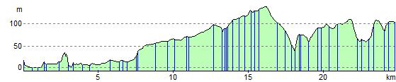
Preston to Pleasington
16.2 miles (26 km)
![]()
![]() This ride follows the River Ribble from Avenham Park in Preston to Samlesbury.
This ride follows the River Ribble from Avenham Park in Preston to Samlesbury.
The ride then follows a series of quiet lanes through some lovely scenery with views of Longridge Fell and the river below. The end point is Pleasington rail station.
Preston to Pleasington Ordnance Survey Map  - view and print off detailed OS map
Preston to Pleasington Open Street Map  - view and print off detailed map
Preston to Pleasington OS Map  - Mobile GPS OS Map with Location tracking
Preston to Pleasington Open Street Map  - Mobile GPS Map with Location tracking
Cycle Routes and Walking Routes Nearby
Elevation Profile