Putney to Coulsdon
15.5 miles (25 km)
![]()
![]() Follow National Cycle Route 20 through south London on this easy ride. The route starts in Wandsworth Park and heads along the Thames to Wandsworth. You'll then head south through Southfields and Earlsfield where you'll join the River Wandle. Here you join the cycle friendly Wandle Trail (mostly off road) through South Wimbledon, Morden and Carshalton. Highlights on the trail include Merton Abbey Mills and the lovely Morden Hall Park and Poulter Park. The final on road section from Wallington takes you through the Oaks Park and Mayfield Lavender farm to the finish point at Coulsden rail station.
Follow National Cycle Route 20 through south London on this easy ride. The route starts in Wandsworth Park and heads along the Thames to Wandsworth. You'll then head south through Southfields and Earlsfield where you'll join the River Wandle. Here you join the cycle friendly Wandle Trail (mostly off road) through South Wimbledon, Morden and Carshalton. Highlights on the trail include Merton Abbey Mills and the lovely Morden Hall Park and Poulter Park. The final on road section from Wallington takes you through the Oaks Park and Mayfield Lavender farm to the finish point at Coulsden rail station.
Putney to Coulsdon Ordnance Survey Map  - view and print off detailed OS map
Putney to Coulsdon Open Street Map  - view and print off detailed map
Putney to Coulsdon OS Map  - Mobile GPS OS Map with Location tracking
Putney to Coulsdon Open Street Map  - Mobile GPS Map with Location tracking
Cycle Routes and Walking Routes Nearby
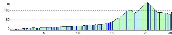
Elevation Profile