Runcorn Loop Cycleway
9.9 miles (16 km)
![]()
![]() Halton BC's 'Runcorn Loop Cycleway'. It forms a loop around Runcorn new town, and can be incorporated into a route to navigate through Runcorn by bike, or as a circular loop - for example started from Norton Priory. It is mostly on cycle tracks except for a half mile section through Whitehouse Industrial Estate.
Halton BC's 'Runcorn Loop Cycleway'. It forms a loop around Runcorn new town, and can be incorporated into a route to navigate through Runcorn by bike, or as a circular loop - for example started from Norton Priory. It is mostly on cycle tracks except for a half mile section through Whitehouse Industrial Estate.
Runcorn Loop Cycleway Ordnance Survey Map  - view and print off detailed OS map
Runcorn Loop Cycleway Open Street Map  - view and print off detailed map
Runcorn Loop Cycleway OS Map  - Mobile GPS OS Map with Location tracking
Runcorn Loop Cycleway Open Street Map  - Mobile GPS Map with Location tracking
Cycle Routes and Walking Routes Nearby
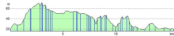
Elevation Profile