Salterns Way
![]()
![]() This super short cycle ride takes you along the Chichester Channel from Chichester to the sand dunes of East Head. The route starts near the centre of Chichester and follows minor roads and off road tracks through Birdham and West Wittering before finishing near the beach at East Head. You will pass attractive marinas and pretty villages while also enjoying terrific views of Chichester Harbour and Hayling Island.
This super short cycle ride takes you along the Chichester Channel from Chichester to the sand dunes of East Head. The route starts near the centre of Chichester and follows minor roads and off road tracks through Birdham and West Wittering before finishing near the beach at East Head. You will pass attractive marinas and pretty villages while also enjoying terrific views of Chichester Harbour and Hayling Island.
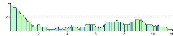
The route runs for a distance of just over 11 miles on a nice flat path. The finish point at East Head is particularly lovely. You can lock up your bike and enjoy a stroll through shingle, sandy beach and a delightful sand dune habitat. The area is great for wildlife with skylarks, ringed plover and common seals to look out for.
Salterns Way Ordnance Survey Map  - view and print off detailed OS map
Salterns Way Open Street Map  - view and print off detailed map
Salterns Way OS Map  - Mobile GPS OS Map with Location tracking
Salterns Way Open Street Map  - Mobile GPS Map with Location tracking
Cycle Routes and Walking Routes Nearby
Photos

Gate on Salterns Way

Chichester Marina.

Driveway to Itchenor Park House and Farm. The road on the left goes to Itchenor Memorial Hall, whilst that on the right is Itchenor Road. The pedestrians are looking at the sign post for the Salterns Way.

Footpath junction along the Salterns Way. Approaching Lock Lane at Birdham.

Salterns Way in Salterns Copse, Appledram

West Wittering
Elevation Profile