Scorton Circular
28 miles (45 km)
![]()
![]() This is a challenging ride taking you around the western edge of the Forest of Bowland.
This is a challenging ride taking you around the western edge of the Forest of Bowland.
The route chiefly follows country lanes around Grizedale and Bleasdale and also takes you through Beacon Fell National Park with some spectacular scenery.
Click here for a leaflet containing this and other Lancashire rides.
Scorton Circular Ordnance Survey Map  - view and print off detailed OS map
Scorton Circular Open Street Map  - view and print off detailed map
Scorton Circular OS Map  - Mobile GPS OS Map with Location tracking
Scorton Circular Open Street Map  - Mobile GPS Map with Location tracking
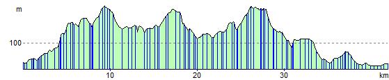
Elevation Profile