Sheerness Way
![]()
![]() Opened in 2011 this super, circular cycle and walking route, follows a series of safe, traffic free paths around Sheerness on the Isle of Sheppey.
Opened in 2011 this super, circular cycle and walking route, follows a series of safe, traffic free paths around Sheerness on the Isle of Sheppey.
You will run along the attractive Isle of Sheppy coast and Sheerness beach, while there is also a pleasant waterside section along the Queenborough Lines or the canal bank as it is known locally. At the eastern end of the route you'll also pass Barton's Point Coastal Park where there's a pretty lake with birdlife and a beach.
This is a nice family cycle ride as it takes place on flat, off road paths. Walkers looking for an easy circular walk will also find it suitable.
The route is easily accessible, starting and finishing at Sheerness-on-Sea railway station.
Please click here for more information
Sheerness Way Ordnance Survey Map  - view and print off detailed OS map
Sheerness Way Open Street Map  - view and print off detailed map
Sheerness Way OS Map  - Mobile GPS OS Map with Location tracking
Sheerness Way Open Street Map  - Mobile GPS Map with Location tracking
Further Information and Other Local Ideas
The Leysdown Coastal Park and the Elmley National Nature Reserve are other good walking options on the Isle.
Cycle Routes and Walking Routes Nearby
Photos

Sheerness Beach

Sheerness Beach from close to Garrison Point. This long shingle beach heads past Sheerness towards Minister.

Queenborough Lines. This "canal" was built in 1860 as a defensive moat to protect the naval installations at Sheerness.

Queenborough Lines - looking east. Built in 1860 as a defensive moat to protect the naval installations at Sheerness. This section joins up with the boating lake at Barton's Point.

Barton's point Coastal Park. There was a battery here, completed in 1890, and the associated basin, connecting with Queenborough Lines, is now used as a boating lake. The ditches were presumably to help drain this rather marshy land.

Barton's point Canal
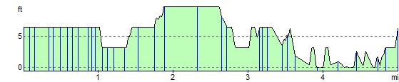
Elevation Profile