Stafford to Stone
10.6 miles (17 km)
![]()
![]() Follow National Cycle Route 5 from Stafford to Stone on this pleasant short ride through Staffordshire.
Follow National Cycle Route 5 from Stafford to Stone on this pleasant short ride through Staffordshire.
The ride starts near Stafford rail station and soon joins a pleasant traffic free section along a dismantled railway line, taking you over the River Sow and through the outskirts of Stafford. You then head into the countryside, following quiet country lanes to Aston-By-Stone. Here you join the Trent and Mersey Canal where you follow the towpath into Stone, finishing near the train station.
Stafford to Stone Ordnance Survey Map  - view and print off detailed OS map
Stafford to Stone Open Street Map  - view and print off detailed map
Stafford to Stone OS Map  - Mobile GPS OS Map with Location tracking
Stafford to Stone Open Street Map  - Mobile GPS Map with Location tracking
Cycle Routes and Walking Routes Nearby
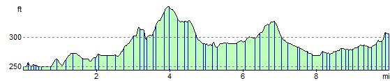
Elevation Profile