Tain to Lairg
26.7 miles (43 km)
![]()
![]() Prepare yourself for some truly breathtaking scenery as you travel along National Cycle route 1 through the Scottish Highlands.
Prepare yourself for some truly breathtaking scenery as you travel along National Cycle route 1 through the Scottish Highlands.
The ride starts in Tain and soon passes the famous Glenmorangie Whisky Distillery before following the stunning Dornoch Firth to Ardgay. You then continue along the Kyle of Sutherland and the River Shin to Shin Forest for a lovely wooded section. The ride continues along the River Shin to Lairg where you can enjoy views of the beautiful loch Shin.
Tain to Lairg Ordnance Survey Map  - view and print off detailed OS map
Tain to Lairg Open Street Map  - view and print off detailed map
Tain to Lairg OS Map  - Mobile GPS OS Map with Location tracking
Tain to Lairg Open Street Map  - Mobile GPS Map with Location tracking
Further Information and Other Local Ideas
Just south of Lairg there's one of the highlights of the area at the Falls of Shin. The beautiful falls are a great place to see salmon leaping during the late summer months. There's also a decent visitor centre, car park and cafe at the site.
Cycle Routes and Walking Routes Nearby
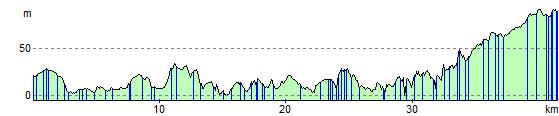
Elevation Profile