The Ridgeway
42.9 miles (69 km)
![]()
![]() This is the cycle friendly opening 43 miles of The Ridgeway - one of the UK's National Trails.
This is the cycle friendly opening 43 miles of The Ridgeway - one of the UK's National Trails.
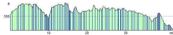
This section runs from Overton Hill, near Avebury in Wiltshire, to Streatley, in Berkshire, on the River Thames. The path passes through some lovely scenery including rolling downland and the woods and valleys of the Chilterns. Highlights on the route includes Wayland's Smithy - a Neolithic long barrow and chamber tomb, and the Uffington White Horse in the Berkshire Downs.
This ride is only really suitable for mountain bikes, taking place on an off road track from start to finish.
The Ridgeway Ordnance Survey Map  - view and print off detailed OS map
The Ridgeway Open Street Map  - view and print off detailed map
The Ridgeway OS Map  - Mobile GPS OS Map with Location tracking
The Ridgeway Open Street Map  - Mobile GPS Map with Location tracking
Cycle Routes and Walking Routes Nearby
Photos

Start of the route at Overton Hill

Wayland's Smithy
Elevation Profile