The South Downs Way
![]()
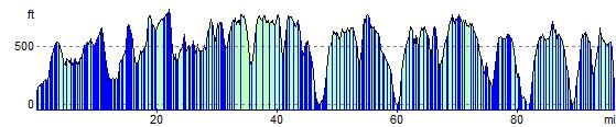
![]() The South Downs Way is a long distance footpath and bridleway. The undulating path begins in Winchester and moves past Cheesefoot Head, the towns of Petersfield and Arundel, the market town of Steyning, Devils Dyke viewpoint near Brighton, and miles of chalk downland, finally ending in Eastbourne.
The South Downs Way is a long distance footpath and bridleway. The undulating path begins in Winchester and moves past Cheesefoot Head, the towns of Petersfield and Arundel, the market town of Steyning, Devils Dyke viewpoint near Brighton, and miles of chalk downland, finally ending in Eastbourne.
The South Downs Way Ordnance Survey Map  - view and print off detailed OS map
The South Downs Way Open Street Map  - view and print off detailed map
The South Downs Way OS Map  - Mobile GPS OS Map with Location tracking
The South Downs Way Open Street Map  - Mobile GPS Map with Location tracking
Pubs/Cafes
In Arundel head to the St Mary’s Gate Inn. The pub has a fascinating history having been built in the 26th year of the reign of Henry VIII in 1525. The two other letting rooms which have been part of the building since the 16th century housed Oliver Cromwell and his guardsmen during the mid-1600. The pub has a great menu, good selection of ales and a cosy log fire. You can find it near the castle on London Rd at Postcode BN18 9BA.
The Red Lion on the High Street is another great option. This one dates back to the 18th century and includes a large beer garden to relax in. You can find it at postcode BN18 9AG.
In Petersfield you can stop for refreshments at The Old Drum on Chapel St at postcode GU32 3DP. The contemporary country pub is located in the centre of Petersfield and has a lovely beer garden. Built in the 18th Century, it is the oldest in the area and has been beautifully restored to keep its character and charm.
Cycle Routes and Walking Routes Nearby
Elevation Profile