The Three Shires Way

 The Three Shires Way is a long distance bridleway which runs between Tathall End in north-east Buckinghamshire and Grafham Water in Cambridgeshire. The shared cycling and walking route traces the outline of ancient trackways and passes through a beautiful rural landscape. Along the way it skirts several small, historic villages, meanders through remnants of ancient woodland, and has many spectacular views.
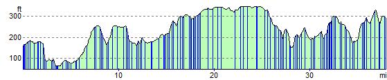
The route is (sometimes) signposted with the Three Shires Way logo and officially runs for 37 miles, though it's nearer 39 miles long if starting/finishing at the Grafham Water Car Park.
I'd recommend cycling north to south (unless faced by a strong south or south-west wind), hence :
Start at Grafham Water Car Park, Cambs : TL166680
Finish at Tathall End, Milton Keynes : SP820468
A circular route around Grafham Water is also available, which extends the total distance to almost 47 miles.
It passes through Easton, Spaldwick, Covington, Shelton, Yielden, Knotting, Lavendon and Emberton before arriving at Tathall End. It is generally a quiet rural route, much of it on clay and very muddy at certain times of the year. Some parts are classified as a 'Byway Open to All Traffic' or a 'Road Used as a Public Path' (generally open April to October), and are therefore legally accessible by motor vehicles. These tracks can be very rutted indeed; a notable example is Forty Foot Lane. Beware!
Note : Mapped on the 1:25,000 series
Submitted by:Mark Worthington
November 2008
The Three Shires Way Ordnance Survey Map  - view and print off detailed OS map
The Three Shires Way Open Street Map  - view and print off detailed map
The Three Shires Way OS Map  - Mobile GPS OS Map with Location tracking
The Three Shires Way Open Street Map  - Mobile GPS Map with Location tracking
Cycle Routes and Walking Routes Nearby
Photos

Three Shires Way heading to Littless Wood on the Western side of Grafham Water

Public Byway heading to Spaldwick

The trail leaves Podington Airfield. Forty Acre Wood is seen in the background.

Public Byway with Restricted Byway heading up to Stow Longa

Farm track through Highfield farm. An off road route for National Cycle Network 12 and 51. It is also the route of the Three Shires Way.

Oak trees by Dungee Wood, near Bozeat View from the footpath. The hedge separates two wheat fields.

Straight & Narrow. The thin strip of grass between the ploughed field and the copse is part of both the trail and the Ouse Valley Way.

Near Bunkers Hill
Elevation Profile