Totnes to Salcombe
![]()
![]() Follow the Dart Valley Trail and other tracks and minor roads through the beautiful Devon countryside from Totnes to the Salcombe ferry.
You start in Totnes and follow the trail along the River Dart before heading on road through Blacklawton and Slapton to the coast.
Follow the Dart Valley Trail and other tracks and minor roads through the beautiful Devon countryside from Totnes to the Salcombe ferry.
You start in Totnes and follow the trail along the River Dart before heading on road through Blacklawton and Slapton to the coast.
A lovely coastal section then follows through Slapton Sands to Torcross with some splendid scenery to enjoy. You then head inland towards Salcombe on quiet roads via Chivelstone.
Totnes to Salcombe Ordnance Survey Map  - view and print off detailed OS map
Totnes to Salcombe Open Street Map  - view and print off detailed map
Totnes to Salcombe OS Map  - Mobile GPS OS Map with Location tracking
Totnes to Salcombe Open Street Map  - Mobile GPS Map with Location tracking
Pubs/Cafes
The Maltsters in Tuckenhay is a nice place for a pit stop. The 18th century pub is located in a lovely riverside spot with fine views over the wide quay. The pub featured in The Times ‘Best 50 Places to Eat Al Fresco’ and was described by The Independent as ‘One of Britain’s Best Riverside Locations’. The pub was once owned by the famous TV chef Keith Floyd. They serve fine food and also provide good quality accommodation.
Very near to the village there's also the Sharpham Estate, a Grade I listed Palladian villa with parkland, gardens and woodland. The estate is now run as a mindfulness retreat but is open to the public on certain days.
Cycle Routes and Walking Routes Nearby
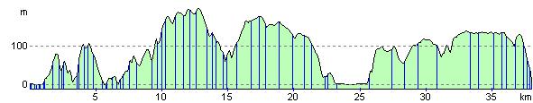
Elevation Profile