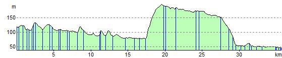
Warminster to Salisbury
23.6 miles (38 km)
![]()
![]() This route starts at Warminster train station and soon joins the Wiltshire Cycleway Wylye Valley route at Sutton Veny.
This route starts at Warminster train station and soon joins the Wiltshire Cycleway Wylye Valley route at Sutton Veny.
After a few miles you'll enter a lovely off road stretch through Grovely wood just outside Wilton before following the Wiltshire cycleway from Wilton to Salisbury. The ride finishes with views of the River Avon before finishing just outside the famous cathedral.
Warminster to Salisbury Ordnance Survey Map  - view and print off detailed OS map
Warminster to Salisbury Open Street Map  - view and print off detailed map
Warminster to Salisbury OS Map  - Mobile GPS OS Map with Location tracking
Warminster to Salisbury Open Street Map  - Mobile GPS Map with Location tracking
Cycle Routes and Walking Routes Nearby
Elevation Profile