Welwyn Garden City to St Margarets
12.4 miles (20 km)
![]()
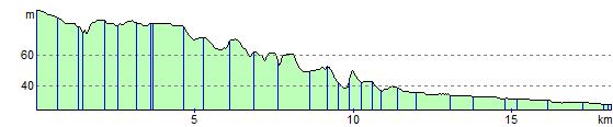
![]() This pleasant ride along National Cycle Route 61 is mainly off road running along the Lee Valley Walk and cycle path from Welywn Garden City to Hertford. You then join the River Lee for a lovely easy stretch along the towing path which takes you on to Ware and then St Margarets, finishing by the train station.
This pleasant ride along National Cycle Route 61 is mainly off road running along the Lee Valley Walk and cycle path from Welywn Garden City to Hertford. You then join the River Lee for a lovely easy stretch along the towing path which takes you on to Ware and then St Margarets, finishing by the train station.
Welwyn Garden City to St Margarets Ordnance Survey Map  - view and print off detailed OS map
Welwyn Garden City to St Margarets Open Street Map  - view and print off detailed map
Welwyn Garden City to St Margarets OS Map  - Mobile GPS OS Map with Location tracking
Welwyn Garden City to St Margarets Open Street Map  - Mobile GPS Map with Location tracking
Cycle Routes and Walking Routes Nearby
Elevation Profile