Whitegate Way
![]()
![]() A lovely, short cycle or walk on a disused railway line, running from Cuddington to Winsford through the Cheshire countryside.
A lovely, short cycle or walk on a disused railway line, running from Cuddington to Winsford through the Cheshire countryside.
You'll pass woodland, lakes and the River Weaver while enjoying fabulous views of Cheshire. The route finishes in Winsford where there are a number of pretty lakes and an 18th century canalside pub.
Around Newchurch Common you could create a little circular walk by heading arund the pretty lakes of the Marton Sands Nature Reserve.
There are rail links at either end and a car park with toilets in Winsford.
Postcode
CW8 2TD - Please note: Postcode may be approximate for some rural locationsPlease click here for more information
Whitegate Way Ordnance Survey Map  - view and print off detailed OS map
Whitegate Way Open Street Map  - view and print off detailed map
Whitegate Way OS Map  - Mobile GPS OS Map with Location tracking
Whitegate Way Open Street Map  - Mobile GPS Map with Location tracking
Pubs/Cafes
At the end of the route in Winsford you could enjoy rest and refreshment at the historic Red Lion. The red brick pub dates from the 18th century and serves good quality food. If the weather is fine you can sit outside and enjoy your meal with views over the River Weaver. You can find them at 1 Wharton Road with a postcode of CW7 3AA for your sat navs.
Cycle Routes and Walking Routes Nearby
Photos

Nunsmere. Nunsmere viewed from old lane leading from Kennel Lane Bridge on Whitegate Way towards Abbots Moss.

Former station sign preserved beside Whitegate Way

Looking South past the picnic area

Grange Lane. Here a railway bridge has been demolished (part of the brick abuttment can be seen left of shot) so the recreational route descends to cross Grange Lane. View looking west towards the terminus at Cuddington.

Winsford. This is the start/finish of the Whitegate Way, a permissive recreational route for walkers, horse riders and cyclists. It follows the line of an old salt-carrying railway line between Winsford and Cuddington (near Delamere Forest) that operated for almost one hundred years before closing in 1966. Here there is a car park off Bradford Road with an interpretation board. The sign to the left of shot marking the terminus appears to be one of the old station platform signs suitably annotated.

The trail crosses Whitegate Lane

Catsclough

Former station masters house
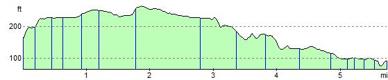
Elevation Profile