Winchester to Farnham
32.9 miles (53 km)
![]()
![]() Travel from Hampshire to Surrey on a series of country roads and off road tracks on this fairly challenging route.
Travel from Hampshire to Surrey on a series of country roads and off road tracks on this fairly challenging route.
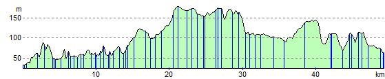
The route starts by Winchester bus station and follows the Rivers Itchen and Alre to New Alresford. On this section you will pass the striking Avington Park and Arlebury Park country houses. The route then continues to the town of Alton before a pleasant off road stretch through Alice Holt Forest.
The final stretch takes you into Farnham on quiet roads.
Winchester to Farnham Ordnance Survey Map  - view and print off detailed OS map
Winchester to Farnham Open Street Map  - view and print off detailed map
Winchester to Farnham OS Map  - Mobile GPS OS Map with Location tracking
Winchester to Farnham Open Street Map  - Mobile GPS Map with Location tracking
Cycle Routes and Walking Routes Nearby
Elevation Profile