Windermere-Circular
![]()
![]() This circular route takes you through some lovely Lake District scenery as you travel around the beautiful Lake Windermere.
This circular route takes you through some lovely Lake District scenery as you travel around the beautiful Lake Windermere.
The route passes through the villages of Ambleside, Grasmere and Elterwater and exposes you to some stunning views.
Highlights are the spectacular lakeland scenery around Windermere including Rydal Water, Grasmere Lake, Esthwaite Water and the lovely wooded section through Hawkshead Hall Park.
Windermere-Circular Ordnance Survey Map  - view and print off detailed OS map
Windermere-Circular Open Street Map  - view and print off detailed map
Windermere-Circular OS Map  - Mobile GPS OS Map with Location tracking
Windermere-Circular Open Street Map  - Mobile GPS Map with Location tracking
Pubs/Cafes
The Britannia Inn in Elterwater is a pub of some note with an interesting history. It was built approximately 500 years ago as a gentleman's farm house and then converted to an Inn sometime during the 19th century. There's a cosy open fire for winter days and a nice beer garden for fine summer days. It's located in a very spot in the little village with a postcode of LA22 9HP.
Cycle Routes and Walking Routes Nearby
Photos

Lake Windermere MMB A7 Bowness-on-Windermere

Lake Windermere MMB 61 Bowness-on-Windermere
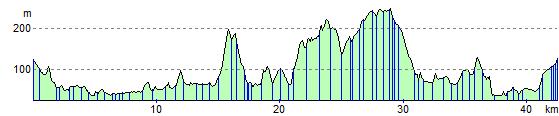
Elevation Profile